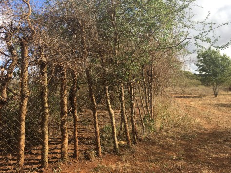
Field work has been in full swing since I last wrote. Last week, along with my students, I worked to finish the fence assessment and put up all of the camera traps. Unfortunately, we didn’t quite finish for several reasons: First, because the fence around the park is a lot longer than you would think, considering Lake Nakuru National Park is a mere 173 square km; Second, because the road around the inside of the fence is impassable in many places. My newfound manual driving skills were put to the test, with multiple obstacles, such as huge holes, bushes, volcanic rocks hidden in the grass, and, of course, the mud. On Monday, we got stuck for what is likely going to be the first of many times over the course of my fieldwork. It took us an hour of building our own “road” out of dead branches, pushing the car, and mud flying everywhere for us to work our way out- I was very proud of our teamwork!
We have about 1/3 of the fence left to assess, and have already discovered a multitude of weak spots with signs of animals crossing. Also, likely because of funding issues, some areas of the fence are not currently electrified although it is supposed to be a fully electric fence. As we put up the cameras, it has been a great experience to try to teach the rangers and KWS staff about camera trap placement and set-up. All of the rangers we’ve met so far have been very accommodating, and our brief moments of rest are often filled with relaxation and copious canned fruit and army rations.
A brief break for bottle cap checkers with KWS rangers
Adventures in Nairobi
Last Wednesday morning, I headed to Nairobi to participate in a two day meeting at Kenya Wildlife Service HQ to brainstorm the new 5-year national strategy for lions and spotted hyena. It was a lucky turn of events that led me to be in a room of about 40 lion and spotted hyena researchers, conservation biologists, and KWS wardens and executives, to discuss the future of KWS policy and action concerning these two species. Along with talking with many people who I’ve long wanted to meet, we had several small group activities in which we brainstormed conservation priorities and challenges for lions and spotted hyenas, and tried to decide how to democratically weave our ideas into the new strategy.
My new lil’ car!
On Friday, I had a “free day” to go and check out a potential field vehicle I had been hearing about- being sold by a friend of a friend named Bali. Luckily, my colleagues Nina and Kat were with me, and Nina was able to test drive the car for me in Nairobi since I don’t yet trust myself to drive in a city with so few traffic rules. The car seemed like a good fit – small but formidable for off-road driving, which I’ll be doing a lot of during my field work. SO I’m currently in the process of purchasing my very first car! Exciting, and a little scary!
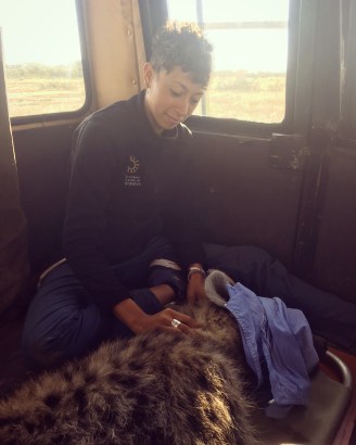
My first hyena darting
Lastly, the biggest event of my week: since Friday, I’ve been staying with the Mara Hyena Project in the Maasai Mara National Reserve, whose founder, Dr. Kay Holekamp, has graciously welcomed me to be trained on various protocols that I intend to adapt for my
Benson prepping the dart.
own research on spotted hyenas. Particularly I’ve been getting trained on dart preparation and darting by Benson, a long-time Kenyan research assistant here who is likely the best hyena darter in the country or maybe even the world. After a few days of rain scares and of unsuccessfully searching for the perfect darting candidate (ie. one that 1) hasn’t been darted before, 2) isn’t near other hyenas since we don’t want others to see us and become frightened of us, 3) isn’t near dangerous animals or bushes or water or tourists), this morning we finally found an eligible hyena and successfully darted him. After darting TIQ (a young male whose full name is Tawfiq after a location in nearby Talek town), it was important to freeze and remain completely silent so he wouldn’t associate the dart’s “bite” with our car or us. Once he went down, we were very quiet and worked quickly to conduct the protocol: first cover his eyes, then collect blood samples, several swabs (anal, nasal, paste, etc.), saliva, hair etc., check for injuries, wounds, and parasites, conduct numerous body and dental measurements and take his weight. Finally, we put him in our car and transported him to a safe place for recovery. Later this evening we will check on him to assure he has recovered successfully.
Research assistant Allie and Benson carrying TIQ to a flatter space for us to work.Keeping his eyes covered as we near the end of the measurements.Conducting body measurements.
The darting experience was a landmark in my field work and an excellent learning experience, since I am intending to dart and outfit spotted hyenas in my study area with GPS-GSM collars. I felt it was my responsibility to learn proper protocols for the safety of the hyenas involved, as well as the best ways to allow my hyenas to still be observable and unbothered by my approach for behavioral observations later on. Many thanks the Mara Hyena Project for hosting me! Now onward, to my own hyena research.
After a year (or more?!) of applying for numerous permits and grants, playing in the Bart station for extra research money, fine-tuning methodologies, and going through human subjects and animal care and use protocols, my dissertation field work has finally begun. I feel like I could write an entire blog post about the preparation process and bureaucracies involved, but that would have an extremely limited audience (students trying to do wildlife research in Kenya?), so I’ll focus on the exciting stuff and bore folks another time.
The past 12 days have been a whirlwind. After disembarking in Nairobi from 26 hours of flying, and 36+ hours of no sleep, I went straight to Savannah Tracking Ltd, the company that has been designing the collars I intend to outfit on spotted hyena in the coming weeks. Although I was exhausted, I chugged a ton of coffee and spent 2 hours getting trained up on the proprietary software system they use for managing their collars. My excitement about seeing my nearly finished collars hanging in the shop contributed to my ability to stay awake for the training, and somehow I ended up in an hour-long deeply philosophical conversation with Daniel, who was training me on the collar software. Just goes to show I’m not ever one for small talk.
Logistics planning started immediately the day after I arrived on Soysambu Conservancy. I learned how to drive stick shift in about 2 hours in a huge Range Rover, from Nina, a researcher here who is graciously letting me borrow her car while I search out my own.
View from my new room!
The best way to learn is to just do it, and I’ve already logged over 35 hours of driving manual in this behemoth in just one week! Additionally, I worked and sweated with Nina and two new friends I’ve made, Dennis and Sora, to clean out and organize a sweet little cottage here in Nina’s camp that otherwise was being used as storage – and which has started to become my new home.
I’ve met a number of people in the past week with whom I’ll be working directly or indirectly, including Soysambu conservancy and livestock staff, Kenya Wildlife Service science and community staff and rangers, various community members, and of course the two Kenyan master’s students from Egerton University who have signed on to my project: Gerald and Christine. In the hopes of doing participatory research properly, it’s extremely important to me to train and build up these students and also to communicate consistently with the communities in which we work, thus assuring we’re at least trying to actively listen and be helpful in the work we’re doing.
Mercy- KWS ranger and new friend, goofing for the camera.
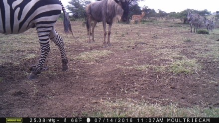
Going into Lake Nakuru National Park for the first time as a researcher rather than a visitor was quite the experience. The power of the single, unassuming piece of paper that is my research permit is amazing, and my passage through the park has been more than facilitated. Luckily, my only struggle has been keeping track of the names of all of the folks I’ve met during my travels there. On Monday, I spent 12 grueling hours driving off-road (and occasionally walking) around the perimeter of the park with a KWS scientist and ranger, mapping weak points of the fence and putting up camera traps to see which carnivores are crossing to and from the community lands. Lake Nakuru National Park is fully electrically fenced, yet there are many weak points in the fence due to rivers and flooding, as well as due to the lowest electric wire not being live, so animals dig under it easily. During our assessment, I even saw a grazing goat from the community shimmy it’s way under the fence from the national park back to the community lands. There were several areas where the road was completely underwater, so the plan is to take a couple of rangers and hike through the bush to assess the remainder of the fence and complete the camera trap placement this and next week.
Placing camera trap at Nderit River, with electric fence elevated nearly 2m off the ground.
This week, I’ve also begun verifying land cover on Soysambu, and teaching my student Gerald how to conduct prey density transects since that is going to be a part of his thesis. I’ve spent much of my time training Gerald and Christine on various field techniques and some of the participatory methods we’re going to use, even as I continue to decide on and train myself on certain aspects of my methodology- thus it has been quite the whirlwind! However, I’m very excited about the students. Their professors have asked me to challenge them and make them work hard, get dirty, and gain field skills. I’ve already noticed they don’t even have sturdy bush shoes or backpacks and Christine has even showed up to field days in designer jeans (!), so we have our work cut out for us…
Lastly, today my hyena collars finally arrived! I am so grateful for my grants and for various crowdfund donors I’ve had who have led me to be able to have these collars custom-designed for my work. Hopefully I will outfit 8-15 hyenas by mid-July, and start to see where they’re moving throughout these different management zones and through the community.
Collars!
It is amazing what a lot of hard work and openness to opportunity will do for you if you keep at it. When thinking about my journey in preparing for this research, I’m reminded of Amanda Palmer’s book “The Art of Asking”, which inspired me to lose my fear of being vulnerable and instead ask for help and guidance when I need it. Hopefully this principle will continue to guide me as I step out of so many comfort zones and dive more deeply into this learning experience. Stay tuned!
Since my time here in Tanzania is almost at an end, I figure it’s about time I write a post about what exactly I’ve been up to this whole time. A large chunk of my work here boils down to conducting a survey on the social implications of a human-wildlife conflict intervention. But there’s a lot more complexity behind the curtain.
Many of you may know that I work on human-wildlife conflict, and feel passionate about interdisciplinary approaches as being the most effective for alleviating conservation issues. Yet, as someone with a background in ecology, conservation biology, and animal behavior, I decided to take a detour from my dissertation research to participate in a summer practicum with the Northern Tanzania Rangelands Initiative (NTRI), and gain more field experience with social science. In particular, I have been working with Tanzania People & Wildlife (TPW) to try and understand the social impacts of their successful (99.9% of reduction in wildlife attacks on livestock) human-wildlife conflict intervention: the Living Walls. The Living Walls consist of planted Commiphora trees surrounded by chain link fence. They act as a much more effective alternative to traditional livestock enclosures, or bomas, and are a community-co-created and environmentally-friendly solution to livestock being attacked by wild carnivores.
A Living Wall in Loibor Siret
Although there are many effective interventions for resolving human-wildlife conflict, very rarely do we attempt to measure the impacts of human-wildlife conflict resolution on human health, economic factors, and gender dynamics. TPW’s Living Walls intervention provides us with an ideal and unique opportunity to assess such social impacts. However, particularly if there is no baseline pre-intervention data on social factors, this is much easier said than done…
Challenge 1: Creating the Survey
In March, my colleague, Steven (from the University of Dar es Salaam), and I set out to figure out how we might develop a survey that would be able to get at the social impacts (if any!) of the Living Walls, as well as the effects of the Living Walls on pastoralist tolerance for wildlife. For about 3.5 months, I took the lead on creating the survey, and it subsequently underwent countless revisions from multiple TPW and other NTRI staff. In order to design a survey that would be effective, incorporate social/health/gender factors, and not waste many peoples’ time, we were tasked with philosophizing about and answering difficult (and sometimes unexpected) questions such as: How can we measure impact without having baseline data? What is the difference between tolerance and attitudes toward wildlife, and which of these is more feasible to study? What counts as a “household” in Maasai-land (where families and friends may live together in the same boma)? … And countless other conceptual and logistical questions. Even before I arrived in Tanzania, devising the survey was teaching me more about the deep and complex levels of thinking needed for social science research, particularly social science research among different cultures and landscapes.
Challenge 2: Translation and Finalizing
Once we arrived at TPW’s headquarters – Noloholo Environmental Center on the border of Tarangire National Park -, and completed multiple survey conceptualization meetings with the co-directors of TPW, Laly Lichtenfeld and Charles Trout, our next step was to finalize the survey and translate it into Kiswahili and Kimaasai. Our plan was to translate the survey from English to Kiswahili to Kimaasai, and then back-translate all the way back to English, to ensure the meanings of the questions were not lost. For translation and back-translation, it is crucial to have different people perform each step, and ideally those will be people who are not at all involved in the survey design. Finding bi- and trilingual people at Noloholo wasn’t difficult, but they all had existing busy schedules and our survey was pushing an hour in length. Nevertheless, we somehow managed to translate, back-translate, and pre-test the survey at camp within the span of a few days. After “trimming the fat” from the survey to bring it under 1 hour in length, we were finally ready to create our sampling plan, find field assistants, and do some field pre-testing.
Challenge 3: Creating a Sampling Plan and Understanding Gender
Because there was no baseline for health, social, and gender factors at Living Wall bomas before they had Living Walls, it was necessary for us to sample bomas without Living Walls as well – which we termed “Non-Living Wall (NLW) bomas”. To attempt to get at the differences, we decided on a paired sampling plan consisting of a Living Wall boma and the closest NLW boma.
We also felt it was important to be able to discern gender differences in survey responses. For instance, women have completely different household roles than men; women may gather and transport wood to fix the boma, take care of the household chores, sell excess cow’s milk at the market and thus have their own money, etc., not to mention the underlying gender power dynamics within each household. So having a Living Wall (due to boma maintenance time saved, fewer livestock lost to wildlife attacks, etc.), is likely to affect women differently than men. But how to quantify these differences in a largely patriarchal culture? The men of the household are more likely to volunteer for the survey, and even if a woman happens to volunteer, it is likely she would have her husband standing over her as she answers the questions – which, of course, would affect her answers. Thus, we came up with an excellent solution: At each boma, interview a man and a woman at the same time, separately from each other, and use a female field assistant for the women’s interviews. Although our boma sample size would be cut down (from 200 bomas to 140 due to time constraints), we would have true gender representation from all of the bomas. Now, we just had to find a male field assistant and a female field assistant.
Challenge 4: Politics and Field Assistants
Steven coaching Edward on the survey app
With the help of the staff and community members, it wasn’t too hard to find field assistants who were bi- or trilingual, literate, and knew how to use a smartphone (for the survey app). We invited our two new field assistants, Edward and Rebecca, to Noloholo for training on survey implementation before heading out for a day of pre-testing in the field. However, before doing any work in our two villages, Loibor Siret and Narakauwo, it was crucial to meet with the mwenyekiti (chairperson) for each village, to get approval and make them aware of what we intended to do. Especially as a foreigner (called mzungu here), I’ve always found that you never know what to expect when talking to local political forces, so, as usual, I was somewhat wary of these meetings. Yet, even with tumultuous politics happening in Narakauwo, this process went surprisingly smoothly. We were then in the clear to field test the survey with Edward and Rebecca.
Mzee Leposo Noongululu (our first pre-test interviewee), and his youngest of 40 children.
The field testing turned out to be very necessary and very productive. Steven and I had a chance to see how the field assistants performed in a real survey situation, and we were able to give them feedback on various aspects of their technique: how to avoid probing (and instead ask the question exactly as it is written), how to work through logistical issues with the phones and with Open Data Kit app, and (specifically for Rebecca) to make sure that women interviewees were answering the questions with information about themselves, rather than about their husbands. After some more practice, and several revisions to the survey resulting from the pre-test findings, we were ready to begin the survey in earnest.
Challenge 5: Getting Around
So, we were ready to go, but there were a few issues. For one, how should we find the Living Wall bomas that are in our random sample? We had GPS points, yes, but we luckily also had the names of the boma owners, which proved to be much more useful. By enlisting the chairman of each sub-village (or their designee) within Narakauwo and Loibor Siret, we were able to easily contact boma owners ahead of time, and find their respective bomas, since the sub-village chairmen know everybody in their sub-village, and know where each person lives. Rather than enlisting more field assistants, we used our budget to pay these chairmen and their designees for each day that they rode with the team and helped find people for the survey. Additionally, although we had originally chosen our paired NLW bomas using high-resolution satellite imagery, we found that it was easier to simply go to the closest NLW boma for each Living Wall boma that we surveyed, and give them a heads up that the team would be coming by the next day to conduct the survey. These two elegant solutions helped immensely, given our small time frame for getting the survey done.
Additionally, we got extremely lucky that we had access to one of TPW’s vehicles for every day we had scheduled for the survey. We had a decent chunk of funds designated for paying for vehicles (normally $150-200/day to rent a vehicle (!), yet TPW gave us a nice discount since we were working on a project relevant to them), but the organization has many projects and we weren’t guaranteed vehicle availability each day. Simply traveling around the bush, over rough roads with plenty of opportunity for flat tires and other vehicle malfunctions, is taxing for both the drivers and the cars, and our survey involved traveling from 7:30am-6:30pm, 6 days a week. Transportation isn’t something to take lightly here in the bush, and I tried to show some extra gratitude by purchasing small gifts for our helpful drivers.
Loibor Siret village center (and one of the flattest/nicest roads around)
This past Saturday was the last day of the survey, after about one rapidly-paced month. We met our sampling goal, employed some great folks as field assistants, and collected a ton of data. It felt amazing to see the survey to completion after months of preparation, and now we get to start our analyses before presenting preliminary results to TPW and to the rest of NTRI at The Nature Conservancy headquarters in Arusha on Monday! We’ve done many more things here, which can be saved for a later blog post, but one thing I’ve learned for sure: There is a lot more complexity than meets the eye behind implementing a survey- especially a survey that tries to discern the connections between human-wildlife conflict resolution and social factors, and especially a survey conducted in a different culture, in multiple languages, in the bush.
Since I left for Tanzania on May 26th, I have had one hot shower, which was also my only shower in the past month in which I’ve used more than 1.3 gallons of water.
Here at Noloholo Environmental Center, which is Tanzania People & Wildlife’s (TPW) headquarters in the Simanjiro District, water is scarce. The region is experiencing an ongoing, uncharacteristic, likely climate change-induced drought, and the effects are immensely noticeable everywhere you look. Most, if not all, of the people living in nearby villages are pastoralists, and almost everyone has lost many cows, sheep, goats, and donkeys due to lack of water and graze for their livestock. This year, the spring rainy season (normally 2-3 months long) never came. Unlike many places in the Western world, water availability and use is, by extreme necessity, at the forefront of everyone’s minds here.
Overlooking dry savanna grass in Tarangire National Park, a stones throw from Noloholo.
Because Noloholo is an integrated part of this community and landscape, and gets much of its water from the closest village (Loibor Siret, a 30 minute drive away over rough road), here at the camp, shower and laundry water is only available from 7:00-7:15am.
My 10-liter water bucket.
Each person is allotted a 10-liter bucket that they can fill up, and for those 15 minutes, water flow is literally unlocked by one of the Maasai staff up the hill by the office, and allowed to pass through two spigots near the staff housing. By 7:15, the flow has been locked until the next morning. There have been many mornings when I wanted to sleep in but instead got up before 7am because I knew I needed to take advantage of the “water time window” to shower or to wash the ubiquitous dust from my clothes later in the day. Water collection in this way now feels routine, and is a great way to say good morning to some of the other staff who are also gathered around the spigot bright and early.
Luxurious outdoor shower
My outdoor shower, which I currently share with two other people, consists of a bucket with a shower head sticking out of the bottom. To me, it feels luxurious for a bush shower. In the past, I’ve taken cup-and-bucket showers- using a cup or empty jar to pour the clean water over my body and hair, so to have something resembling a hands-free shower is exciting. Even with the occasionally numbing breeze, its beautiful to shower with birds singing overhead, or (when taking a night shower) with the stunning Milky Way giving me perspective and reminding me that cold showers aren’t so bad. Plus, if I’m able to leave my bucket out until the afternoon, the water gets relatively warm in the equatorial sunlight, and warmish showers are possible!
Okay, back to my PSA. Despite this small water allotment, I’ve come to notice that I consistently only need half of my bucket- 5 liters (about 1.3 gallons) of water – for my showers. And yes, I am able to be completely clean when I shower with that amount of water- even with the pervasive dry-season red dust that penetrates every pore daily. Considering that the average American shower uses 17.2 gallons of water and showerheads have a flow rate of 2.5 gallons per minute, you may be wondering how it’s possible for me to use so little water. Well, for me the key has been turning the shower off when I’m not using it- for example, when I’m soaping up, shampooing my hair, or shaving. My 1.3 gallons per shower translates into 19.5 gallons per month considering I only shower about every other day. Compare that to how many Americans (even me when I’m home- I am not above this!) shower daily and will use upward of 500 gallons/month for showering.
We can do better. Although I’ve spent a lot of time in the bush taking various versions of bush showers, it is only now that I have taken a moment to calculate how much water I really need for my showers. As someone who loves a good long hot shower myself, I hope I can improve the way I approach my showers at home. But, I know behavioral change is hard, especially when we’re talking about our creature comforts. So, if you’re not down for quitting long showers cold-turkey in favor of the “military shower”, why not purchase an efficient shower head, or a thermostatic shut-off valve, and challenge yourself to shorten your showers by a few minutes? Freshwater scarcity is on peoples’ minds here in the savanna, but it should be on everyone’s minds: the world is running out of freshwater,and climate change is only exacerbating the issue. This should be obvious, but freshwater is our lifeline- from agriculture to drinking water- and freshwater shortages around the world are linked deep unrest, war, and of course death. Because we don’t have to walk miles to a borehole for our water, it can be difficult for us to connect with water shortage as a possibility, but Americans need to step up their water-consciousness before it’s too late. Making a few small changes to our shower routines is just one way to contribute!
The ubiquitous red earth, which turns to dust in the dry season.
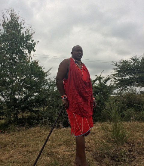
The Maasai people constitute one of the major ethnic groups living in Kenya and Tanzania. Having a pastoralist lifestyle, the Maasai rely heavily on their cattle, sheep, and goats for sustenance, and thus livestock are a Maasai family’s most valuable asset. You may have heard of the Maasai – among many other things, they are known for their ability to jump to impressive heights, and the ceremonial lion hunts (olamayio) historically conducted by young Maasai warriors as a rite of passage. Yet today, we have more and more Maasai like my friend, Nickson Parmisa, a Maasai chief in the Kitengela area, who loves lions and has devoted his life to conservation. Being a chief, Nickson has played an invaluable role in influencing his community’s approaches to conservation. I sat down with Nickson to hear his thoughts about the future of Nairobi National Park and the Kitengela dispersal area.
Nickson Parmisa, Assistant Chief of Athi River North (Empakasi)
As a lifelong resident of the Kitengela dispersal area, what are your thoughts on threats to this area and to the national park?
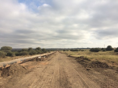
Since the national park was originally gazetted, it has been repeatedly reduced. Along with the controversial railway, there is already a highway bypass that has cut through the edge of the park, and an above-ground oil pipeline currently in construction through the park. The Kitengela region was historically declared a conservation area, but after Independence, the government failed to create legislation to protect the land from subdivision and development. Kitengela’s proximity to the city also subjects it more acutely to development pressures. The Namanga Road, a highway heading south from Nairobi, has significantly contributed to development by making this prime land more accessible, attracting many land speculators. (Authors note: While driving on the Namanga Road, I’ve passed countless “Plots for Sale” signs). Since Kitengela is considered to be essentially a part of Nairobi, but with cheaper prices, many people travel here to live and develop businesses. It doesn’t help that NEMA (the National Environmental Management Authority) has failed to protect the land, allowing previously pastoral or agricultural land to be fenced or converted to quarries, and that many government policies in this area are enacted without community input.
Oil pipeline, Nairobi National Park
What do you think is the future of Nairobi National Park and the Kitengela wildlife dispersal area?
There is hope. People’s perceptions are changing. In the past, people used to see wildlife as a liability or burden, but now many people are seeing wildlife as a resource.
Wow, what’s causing such a big shift?
There have been numerous non-profit programs to try and empower and incentivize this community to allow wildlife free passage on their land. One example is the lease program, which was started by Friends of Nairobi National Park (FoNNAP), and continued by The Wildlife Foundation (TWF). The lease program paid community members to not fence their land, allowing livestock and wildlife to roam freely. As a bonus, the payments coincided with the school opening dates, so the money often went straight to school fees and contributed to many more children going to school. However, the program ended in 2014 due to funding issues, and many fences started going up. People would still be receptive to the lease program if it were funded again, so any potential donors are welcome to contact TWF.
There was also a consolation program, run by FoNNAP, which gave people a small amount of money whenever they lost livestock due to depredation. Additionally, in 2014 the government enacted a human-wildlife bill, which will give compensation when people or livestock are killed by wildlife. However, the compensation program has been slow to go into action. Its true that attitudes are shifting, but money speaks, and if these incentivizing programs are run well, people in this area will be able to coexist with wildlife even more peacefully.
Last, the Nairobi National Park Conservancy is an exciting new initiative south of the park. It consists of a group of landowners who own land bordering the national park, and would like to create a conservancy out of their land. I am part of this conservancy, and with TWF we are working on various funding plans. However, the fact that several landowners want to be part of this conservancy is a good sign of changing feelings toward wildlife.
So it sounds like there is hope, but lots of hurdles as well. Any last thoughts?
Wildlife numbers have increased in this area. Kitengela has become a calving zone, which hasn’t happened in many years. Along with inside the park, wildlife used to give birth in the 2nd Triangle, an area nearby, yet now wildebeest are calving all around the Kitengela region. This is a good indication that people may be doing land use practices that will conserve habitat and bring wildlife back. We will have to keep thinking creatively, but so far the positive signs are there.
Zebra, wildebeest, impala, and livestock, all within 30 minutes in the Kitengela dispersal area.
I’ve lived in East Africa three different times, for a total of a little less than 2 years, and for all that time I’ve been actively, and successfully, avoiding buffalo. Anyone who has visited or lived here knows that the cape buffalo is the most dangerous animal in Africa. Sometimes referred to as “Black Death” or “The Widowmaker”, the cape buffalo is basically a 6 foot tall, 1700 pound, temperamental, unpredictable cow that (surprisingly for its size) can sprint at speeds up to 35 mph if provoked. Over 200 people per year are gored and killed by cape buffalo. So it’s hardly a surprise that I have put considerable effort into avoiding these animals during my time here. But, as they say, you attract what you resist.
Cape buffalo, Nairobi National ParkThis morning, after spending awhile bird-watching from a rock I’ve been calling “lion rock”, due to its frequent nightly visitors, I headed to a tree a few feet away to check my camera trap and then walk back up to Nickson’s house. I looked through some of the photos, secured the camera to the tree, and slowly stood up, only to find myself face to face with a massive cape buffalo standing 10 feet from me.
For about half a second, we both silently froze. Clearly we had surprised each other. Almost immediately, the buffalo broke the silence by aggressively snorting and swinging its head in my direction. This was not good. Heart racing, I reacted with all of the knowledge that’s been engrained in me since my first day here: Don’t run, the buffalo can run faster; Don’t put open ground between you and the buffalo- again, it can run faster; If you can, climb a tree (although buffalos have been known to run up or trample trees in pursuit).
I had to think quickly. There was one tiny shrub and one 2-foot tree between me and the “Black Death”, and hardly a tall tree to be seen nearby. Since the buffalo was blocking my path to the house, I decided to take my chances and go in the opposite direction, toward the national park. There was a serious risk of there being more buffalo in that direction, as buffalo move in herds, but there was nothing else I could do. Of course, all of these thoughts and decisions happened in less than 2 seconds, as this aggressive animal was staring me down. I slowly stepped backward, to half-obscure myself behind a taller shrub, simultaneously keeping my eye on the buffalo, looking for a direction with the thickest shrubs to hide behind, and searching the landscape for the rest of the buffalo herd. Some part of me stupidly secured my belongings to my body (as if they mattered), getting ready to run if I had to. My heart racing, I moved from shrub to shrub as subtly and quickly as I could, noting the potential refuge trees in the area. As I moved it occurred to me that they say, “climb a tree to escape”, but fail to mention the 3 inch long, razor sharp thorns covering every tree in the area.
Sliding from bush to bush, I made a wide arc toward the national park, and then cut through a large zebra herd going back toward the house through an open field. All of this took less than 5 minutes. My heart pounding out of my throat, I looked back in the direction I came from, part of me wondering whether I had imagined the entire thing. But no, deep in the bush, a glimpse of a black tail swinging, and the sharp tip of a dark grey horn.
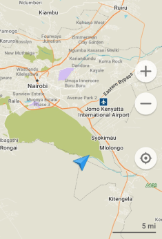
I’ve always thought there was something morbidly beautiful about thick clouds of factory smoke backlit by late afternoon sun. Thus were my thoughts several days ago as my friend Nickson and I traveled to his home on the unfenced southern border of Nairobi National Park, passing belching factories and numerous power line pylons hugging the east side of the park.
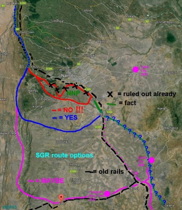
I’m at the blue arrow. That green splotch is Nairobi National Park.
Google Nairobi National Park, and you’re barraged with a series of articles containing the words “only” and “first”. Located directly south of Nairobi, NNP was the first national park in Kenya, gazetted in 1946, acting as the spark for tourism to become Kenya’s greatest industry. It is one of the only places to spot the endangered eastern black rhino, of which about 700 remain. It is also the only national park located in an urban area, and people take a certain pride in saying its the only park where you will be able to take photos of wildlife with skyscrapers in the background. What you don’t hear about are the industrial compounds that may also appear in your photos, and which encroach slowly but ever so reliably onto park land. You also don’t hear that the park is already contained by electric fencing on three sides, open only to a rapidly developing dispersal area over the Mbagathi River to the south.
Since the park only comprises 117 square kilometers, and is so heavily pressed by development, the southern Kitengela dispersal area (where I’m currently residing) is critical for wildlife such as large herbivores and lions to move between NNP and the Athi-Kapiti plains. Although the dispersal area is facing subdivision and other development pressures, there are multiple efforts underway by Friends of Nairobi National Park, WWF, The Wildlife Foundation, and others to incentivize current landowners to keep their lands open and unfenced, giving the wildlife passage.
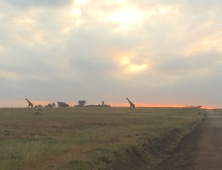
The newest battle for the preservation of NNP has begun over what may be the most devastating development pressure the park has ever faced: a railway running through the park and/or the dispersal area. Developers of the Standard Gauge Railway (SGR) have so far listened to the multitude of angry community members and conservationists, and currently have agreed to divert the railway to the southern border of the park, proposing to build an overpass along the Mbagathi River. Portions of the park have already been de-gazetted for development purposes, and running a railway through the park could have been a fatal blow. However, although it seems as if local conservationists have gained some ground, pushing the railway construction south to the border of NNP would still dramatically impact the thousands of animals moving in and out of the park. This isn’t just about impacting seasonal migrations; every day here at Nickson’s I’ve walked outside to see zebras, wildebeest, impala, and giraffes freely roaming in and out of the park to graze these lands. The most ideal option being proposed by conservationists is a reroute far to the south, which would avoid the dispersal lands, yet Kenyan officials have denounced this as too expensive (which is seeming to not be true). To further make the case for the southmost route, it seems that route is supported by residents in that area, while residents around here are still waiting to be involved in conversations about potential loss of their land- only having received infuriating silence from officials thus far.
Options under discussion for the railway.
Because of these development pressures, many have expressed concern that Nairobi National Park will soon become completely isolated, “like a zoo”. Yet some may argue that this isn’t necessarily a bad thing, and may be inevitable. Although it is of course ideal to maintain landscape connectivity and ecological authenticity if at all possible between parks and reserves, there are many parks and reserves in parts of sub-Saharan Africa that are completely fenced. Many of these parks are managed accordingly, with periodic hunting or culling to maintain populations, and plans in place to prevent genetic inbreeding of wildlife. Of course, many of them are heinously mismanaged as well. Yet research on fenced wildlife reserves and sustainable management of these reserves is only increasing as time goes on, in correlation with increasing development and subsequent habitat and connectivity loss.
I, personally, am interested in creative community approaches to sustaining landscape connectivity and wildlife habitat. I am for the wildlife, through and through, yet I’ve grown to realize that necessitates being for the people as well. As much as I’d like every human to learn to put the needs of wildlife on the same level as their own needs, and fall into rapture at the sound of a hyena yipping on the savanna at dusk or the view of a giraffe silhouetted against the sunset, those aren’t realistic desires. So in this world of more and more humans and less and less of everything else, I’m keeping my mind open about our options.
Last night after dinner I found myself eagerly heading out into the rain with raptor expert and Kenyan native Simon Thomsett, to assist the Kenya Wildlife Service (KWS) with capturing and relocating some “troublesome” lions. Simon and I had already gotten soaked to the bone in the sudden downpour on our walk to exercise his rehabilitated tawny eagle a few hours before, but I was undeterred.
You may be asking, “What constitutes a ‘troublesome’ lion?”, and you are correct in being confused. Although tourists flock to East Africa for a chance to view lions in person, the world’s second-largest cat has long been a cause of conflict for people here who own livestock. Soysambu Conservancy, which is adjacent to Nakuru National Park, also functions as a ranch, home to thousands of the most valuable cattle in the country. Although there is a fence between Nakuru NP and the Conservancy, it has some weak points, and because the national park is continuously encroached upon by development, more and more park lions have made their way to the conservancy for easy meals. The ranch here at Soysambu has been working toward building more secure fences for the nighttime cattle enclosures, or bomas, but, for complex reasons, any boma improvement initiatives have been advancing extremely slowly. Thus, lions can easily pick off the cattle here at the ranch.
As you might imagine, Soysambu Conservancy leaders are interested in the return of more lions, especially since it appears the national park does not have the resources to support its entire burgeoning lion population, so the Conservancy has been working hard to encourage the ranch to build better bomas quickly. However, bureaucratic and, perhaps, monetary concerns are considerable roadblocks. It is no surprise that bureaucratic and political conflict go hand in hand with human-carnivore conflict. As a result of this slow process, KWS has been compelled to constantly come to the conservancy at night and use considerable resources and manpower to bait, dart, and trap “troublesome” lions and return them to the park. Because these operations can last well into the early hours of the morning, the significant loss of sleep for KWS staff is one of many side effects.
Simon and I met KWS at one of the ~18 bomas here on the Conservancy, chosen because lions had been seen there recently, and had been targeting the cattle. When we got to the boma, it was obvious why: the boma was enormous, with the hundreds of cattle only taking up 1/4 of the space, and the fence was constructed of flimsy wire and wood posts. As we drove up, I used an army-grade thermal scope (borrowed- a luxury not usually used in these operations) to see the lay of the land, and saw several calves standing vulnerably outside of the boma- a testament to the insecurity of the structure.
There are a few struggles with capturing wild lions. First, if you don’t tie down the bait (in this case, a calf they had already killed this evening), they will quickly dart in and grab the bait and run away, completely foiling your efforts. In fact, they will often manage to do this even if it is tied, but its a bit more difficult for them. Secondly, and most importantly, lions will flee if you shine a light upon them. Yet, you need light in order to see when to dart the lion, and to make sure it doesn’t steal the bait, and, of course, to make sure you know where its fallen once the drug takes effect. This need for light, more than anything, is what makes these night time relocation operations so longwinded for KWS. So it was that when we arrived with the thermal scope, we were a great asset.
There were four lions for us to dart and bring back to the park. Three members of KWS piled into our car- the one in charge of darting was in the passenger seat, Simon had the spotlight ready in the driver’s seat, and I was crouched out the top hatch with the thermal scope, watching the lions’ every move. I would use the scope to see when one of the lions broke from the group and stalked, ever so slowly, toward the bait, which was under a large acacia tree. All was pitch black except the brightness of the lions and other carnivores lurking around (hyenas, jackals, etc.), which I could see with my scope. As the lion got close enough to the prey, and to our car, at my signal Simon would suddenly shine the spotlight at where I said the lion was, giving KWS the visibility to dart the lion. The KWS officer’s accuracy was on point for each lion, and I used the thermal scope to keep track of where in the bush these lions ended up as they fell. With the accelerant in the drug, it only took 2-10 seconds for the lions to fall, so this part wasn’t very difficult. Occasionally, if the lions were laying down and not making moves toward the bait, we would play hyena calls from our car radio (yes, Simon does have this recorded… don’t even get me started on the pig slaughter screams…), which would lure the lions to action with the risk of their prey being stolen by hyenas.
Friday, a young male
All in all, it took 4 or 5 hours to complete the operation. We took identification photos of the first two lions, and loaded them into the trucks for relocation, then had to wait at length for KWS to return from the national park before we could begin baiting the other two lions. (Side note: lions are as heavy to lift as you think they are…) The last lion seemed sick of it all, and lay down in the bush refusing to take the bait, so I guided the KWS officer to her location with the scope, and, luckily, he managed to make the perfect shot in a difficult circumstance.
Although it was an interesting and exciting night, in the end I felt quite conflicted about the whole thing. With better bomas, its likely that none of this darting and relocating would have to happen. KWS wouldn’t be spending all of their time and resources removing lions from the conservancy, the lions wouldn’t be darted and moved constantly (which, perhaps, is stressful for a lion- its unclear), and the conservancy would be able to act as the wildlife corridor they are so beautifully suited to be. And, with countless herbivores (zebras, impala, etc.), the lions would have plenty of other prey to hunt instead of cattle.
Currently, there are still “approved” lions on Soysambu, as part of the Soysambu Lion Project, which is piloting the effectiveness of boma alarm systems connected to collars worn by the lions. So far, the system seems to be having success, but many more alarms and several more collars are needed for it to scale up to the whole ranch. Coupled with better boma fences, perhaps the Nakuru NP and Soysambu lions will be able to move freely in the not-too-distant future.


 We have about 1/3 of the fence left to assess, and have already discovered a multitude of weak spots with signs of animals crossing. Also, likely because of funding issues, some areas of the fence are not currently electrified although it is supposed to be a fully electric fence. As we put up the cameras, it has been a great experience to try to teach the rangers and KWS staff about camera trap placement and set-up. All of the rangers we’ve met so far have been very accommodating, and our brief moments of rest are often filled with relaxation and copious canned fruit and army rations.